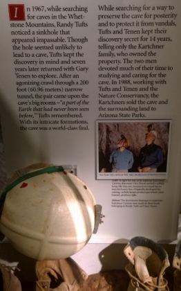
I know you might be saying the last blog was a little too much history so this one will cover more hiking and State and National parks, with a little history mixed in;-) We spent a couple days in an RV park near Huachuca City and caught up on laundry and the blog and then headed to Kartchner Caverns SP for 2 days. We had reserved our campsite and a cave tour of the “Big Room” but we enjoyed the first guided cavern tour so much we then signed up for a second one to the Rotunda and Throne Rooms. We were doing these tours on the Martin Luther King holiday so the first tour was quite full but we were really lucky because by the time we did the second tour everyone had left and we were the only two people on the tour with the ranger for the last tour of the day! This was fantastic because we could ask lots of questions and he even spent longer with us than the normal tour would allow! Unfortunately they do not allow photos to be taken in the caverns so all we got in terms of photos was from the exhibit area plus our memories of a very spectacular wet cave (live, still forming cave).
Randy Tufts saw the sink hole in 1967 but it wasn’t until 1974 that he and Gary Tenen crawled through a very narrow 200’ tunnel and actually discovered the Big Room. Once they found the spectacular formations they knew they needed to preserve the caverns and they worked for 14 years mapping the system and working with the Kartchner family, the Nature Conservancy and the government authorities to finally negotiate a sale of the lands to the Arizona State Parks. In a wet cave the formations are still growing due to the 70 F temperature and the 99% humidity. In a dry cave (like Carlsbad Caverns that we saw last year) the formations have stopped growing because surface air gets in and has dried up all the moisture. In order to keep Kartchner as a wet cave they have many air lock cavities in the entrance tunnels so the outside air can’t enter (one guy on our tour related it to the doors at the beginning of Get Smart). Consequently when you are on the tour it feels very hot and humid inside and you often get cave drips falling on you.
They take you up to the tunnel entrances on an electric train and then go through the air locks to get in to the caverns. The big room tour took 1.75 hours and is only available from mid-October through mid-April because there is a bat species that has its nesting grounds in the cavern so they close the cave when the bats return to give birth. The Rotunda/Throne room tour is 1.5 hours and at the end you get to see the “Kubla Khan” column formation that is 58’ tall! On the tours we saw the usual Stalactites and Stalagmites but we also saw really long soda straws, Helictites, Shield formations, Turnip Welt Shields (first time we had seen these), Fried Egg Stalagmites, Bacon Draperies, Terraced Pools and massive Flowstones, Dogtooth Spare Crystals, and the world’s most extensive formation of Brushite Moonmilk. We also saw some of the narrow passages that Randy and Gary had to fit through and the waste deep mud they had to trek through to reach Kubla Khan. We also saw some live camel crickets and the areas that Myotis Velifer (Cave Bats) hang out and have their young, and of course their large Guano piles! We also saw layers of limestone where there were Crinoid and Horn Coral fossils (just like we find in Cape Croker back home). What a spectacular cavern system to visit and well worth doing both tours.
They also found bones from a Shasta Ground Sloth in the caverns that was dated to 86,000 years old. On a side note the Arizona State Government does not fund their park system at all so all revenues come from fees within the parks (such as camping) and Kartchner funds a large amount through the costs of the tours. We also bought the State Park Annual pass to help this system stay open.
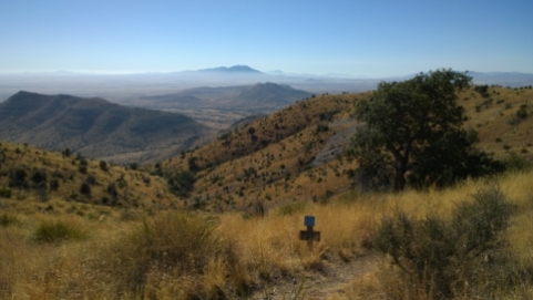
The next day we did an 8 KM hike on the Guindani Trail located on the east flank of the Whetstone Mountains in the Coronado National Forest which is adjacent to the Kartchner Caverns property. This was listed as a strenuous loop hike that climbed in elevation from 4720’ up to a saddle which was 5620’. We were glad we brought our walking poles along as the first half of the trail was rocky and quite steep in parts. On the way up and out of the Guindani canyon we saw two white tailed deer bounding away from us. Once we reached the saddle the views of the Whetstone Mountains and the San Pedro valley were spectacular. There was a bit of haze on the mountains south of Sierra Vista but we could still see them. The topography changes as we went along the hike were quite dramatic with Chihuahuan semi-desert grassland at the bottom, oak and juniper woodland in the canyon, then high desert with agave plants (good nectar for the bats) around the saddle, and then we ended up on an old Tungsten mining road (1930-1950) with lots of interesting rocks.
In the gift shop and in the next RV park we saw some cool shirts and a flag to hang in your campsite.
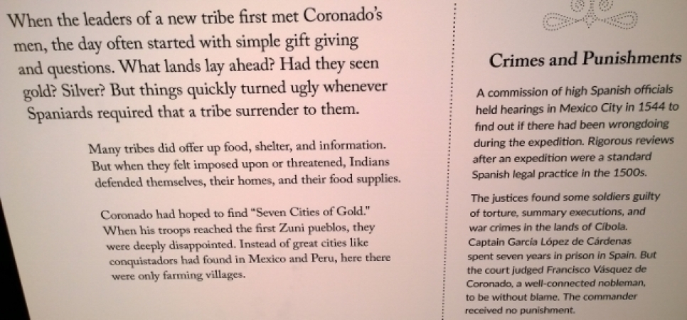
On the day we left Kartchner we had booked back in at the Huachuca Mountain View RV park so we could head south to the Coronado National Memorial to explore it and then return. The drive south from Sierra Vista was quite spectacular with the Huachuca Mountains on the west side. The National Memorial commemorates Francisco Vasquez de Coronado’s Spanish expedition in 1540 to explore the American Southwest. They said it was a missionary expedition but they actually wanted to find the supposed large cities with streets of goldsmith shops. Francisco’s soldiers made it through the south eastern section of Arizona, through New Mexico and all the way to Salina Kansas but gave up in 1542 as they didn’t find any golden cities. However this expedition was very important to explore and map these areas and the priests stayed behind at various locations to try to convert the Indians to Christianity.
At the park they had a gravel switchback road that went up the Montezuma Canyon to the pass/overlook but your vehicle had to be 24’ or less (which we aren’t). Consequently we decided to hike Joe’s Canyon Trail and then go on to Coronado Peak. We were so glad we did this trail as it gave incredible views of the mountains and all the way south in to Mexico! The hike was about 11 KMS total and was quite strenuous at times with an elevation climb of 1634’ (likely our most so far on this trip)! We had a self-imposed time crunch because if you completed more than 5 KMS in the park you got a Coronado Hiking pin, we made it with 30 minutes to spare before the visitor centre closed;-) You just had to show the ranger pictures from your hike which we had lots to show as follows.
Once we were back in the visitor centre they had some interesting displays where we learned about the Spanish influences that the expedition had on the US such as food, that all Chile peppers originally came from America, the background around the Day of the Dead celebration, and we even got to see a live Coatimundi drinking water by the visitor centre.
The following day we were heading to Patagonia Lake SP but on the way we stopped at a fun winery named Arizona Hops and Vines. For their wine tasting you had a sip of wine and then ate a potato chip that paired with the wine and had another sip of wine. She had various flavours of chips and even had Cheetos for one red blend and had Cocoa Puffs paired with a really amazing Cabernet Sauvignon;-) Naturally we bought a few of the wines and looked around at her various art pieces.
Patagonia Lake SP was established in 1975 and the campground overlooks a 265 acre man-made lake that is great for fishermen and also for birders. After we got setup we picked up some hiking maps from the visitor centre and did the lower and upper loops of the Sonoita Creek Trail which was where most of the birds, ducks, and herons could be seen. We had to dodge cow patties along the trail and the actual cows as they were grazing in that area. At the bird feeding stations we saw Cardinals, Pyrrhuloxia, a black Kingfisher with a white collar around his neck, Gnat Catchers and several types of swallows as well as the Grebs and Blue Heron around the lake. Later that night we had a nice sunset.
Our plan for the next day was to ride our bikes from the campground to the Sonoita Creek State Natural Area (established in 1994 to preserve a fragile riparian area and it was Arizona’s first significant Natural Area) that was adjacent to Patagonia Lake and do a loop and an overlook trail (7 KMS hiking and 4 KMS biking). However when we got the bikes out we found I had my second flat tire (of course on the rear) for this trip. Luckily we had spare tube and a spare tire so we replaced both this time instead of using a patched tube. However this delayed our start a bit. The ride up the hill to the Sonoita Creek entrance was quite steep and then it was a gravel road to the trailhead with a 10% grade for the final section. We started off doing the Overlook trail so we could get an overall view of the entire Patagonia Lake. The trail had a few steep sections but nothing like the Coronado hike a couple of days before. Next we took the Sonoita Creek Trail where we saw two white tailed deer and the really cool river canyon before we got to the scenic view of the Spillway Creek water fall. The turnaround point was at Sonoita Creek where we saw an old railway trestle abutment and then we turned onto Blackhawk Trail to return. We got our feet a little wet in order to cross the lake’s spillway and return to the parking lot in order to ride our bikes back (up the 10% grade) to the campground.


Exciting country in Arizona. Love the cave details you gave.
LikeLiked by 1 person
It would have been nice to take photos in the cave but I think they were finding it delayed the tours timing so they don’t allow it now.
LikeLike
Oh, I really enjoyed that tour!! Onward ho and continued safe travels.
LikeLiked by 1 person