As we entered the Phoenix area we were welcomed with a large dust storm that made it very difficult to drive. We also arrived when Phoenix had its winter cool down which made the nights quite chilly, although it was good for hiking during the day.
We made it through the dust storm and arrived at Lost Dutchman SP where we had booked in for 3 nights in a no services site (this SP is very busy and hard to get a site at this time of year). The next day we decided to try out the MTB trail that went around the outer edge of the campground. It turned out to be an excellent trail with lots of drops through wash areas and it had spectacular views of the Superstition Mountains. It was likely around 6 KMS and when we returned to the campsite we did some tune up things for our bikes. That evening we had a reverse sunset on the mountains.
The following day they had a guided Geology hike so we decided to participate. We arrived early and the volunteer had lots of material to hand out. He had clip boards with about 20 pages of notes, pens to give out, and he even had prepared USB keys for us with all of his presentation and note materials (almost felt like we were in school again but there wasn’t a final exam!). He was having trouble remembering some things and he told us he had Parkinson’s disease. Eventually another volunteer arrived to help which was a good thing because the group reached almost 35 people. He first walked us through his notes and explained some of the history of the Superstition Mountains and then we went on a 6 KM hike where he pointed out various rock types and also told us about some of the mining history in the area. Here are some of the facts he relayed:
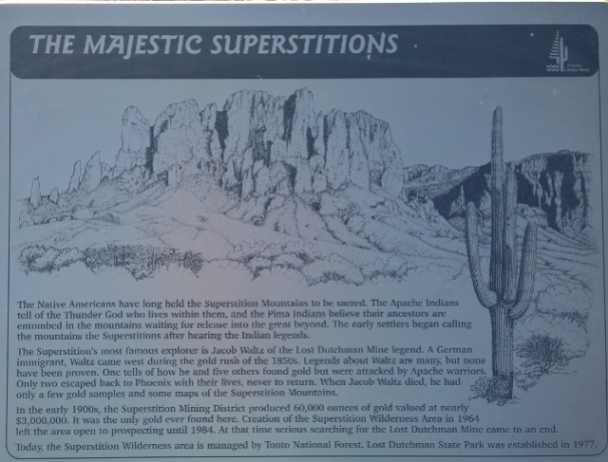
- The Spanish named the mountains the Superstitions in 1540 due to the stories about mysterious incidents of disappearances in the mountains.
- Lost Dutchman SP was setup as a day use area in 1972 and then had full services starting in 1977 (320 acres). Tonto National Forest is right beside the property and is 3 Million acres. Superstition Wilderness area is beside the forest and has 106,200 acres.
- He described how plate tectonics worked and how the Atlantic Ocean is getting larger while the Pacific Ocean is getting smaller as the North American plate slides westward.
- The Superstition Mountains were formed by a very large volcanic explosion 30 million years ago from a caldera that was 25 miles wide. The explosion sent ash as far away as Louisiana!
- When resurgence occurred the magma dome pushed up the Superstition Mountains 4000’ and then erosion over time created the craggy appearance (1000’ removed). The peak called Flatiron however was harder Tuff material and therefore is still a flat surface (we hiked to that summit a couple of days later).
- In the back of his materials he gave us a 10 step mineral identification process so we’ll have to try this in other areas when we find cool rocks.
- There were many stories of rich gold veins in the mountains and people disappearing trying to find the veins but the latest scientific analysis shows that there are no rich gold deposits.
Once he finished the talk we decided to hike up the Treasure Loop trail to Green Boulder and then follow the Prospector’s View trail back to Siphon Draw and in turn back to the campground. As we did the hiking we saw several people on horseback riding on the trails. It’s very hard to get good photos of the mountains as the sun rises behind the side that you are typically hiking on. That evening we had another nice reverse sunset on the mountains from our campsite.
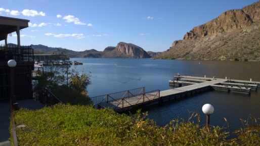
Since we had more hiking we wanted to do in the park we went online and someone had cancelled a primitive site (likely due to the cold overnight temperatures) so we were able to book in for two more nights in a different site. We took advantage of the site move to drive into Apache Junction and do our laundry, however we had to go to 3 laundry mats before we got in. The first one had a bus of Mexican workers who had just been dropped off to do their laundry. The second one had nowhere we could park the RV so we found a third one that wasn’t busy and had parking. After finishing our 4 loads we decided to drive to Canyon Lake and have lunch at Tortilla Flats. The drive was spectacular but when we arrived in Tortilla Flats a lot of people had the same idea so we couldn’t get any parking so we got turned around and went back to the Marina to have lunch. There was a paddleboat steamer that toured Canyon Lake but we didn’t have time to do it so we’ll have to do that another time. On the way back to the SP we did a short walk in to see Weaver’s Needle, in the distance.
The following day we had decided to do take the Siphon Draw trail into the basin and hike to Flatiron. Sharon planned to turn around at the basin while I continued on up to the summit of Flatiron. The trail to the basin followed the Siphon Draw canyon and had a 1000’ elevation gain to the basin. The trail to Flatiron summit had an additional 2000’ of elevation gain and was listed as “only experienced hikers in good shape should attempt this hike”. I read after the fact that some rate this hike as the second hardest in all of Arizona! We started early and reached the basin in fairly good time and it turned out 6 older people were coming back down the basin when we arrived. They had only climbed to the saddle but their lead person said he had done the summit in the past and he convinced Sharon that she could complete the whole hike. After we reached the saddle we could see the trail went up a rocky wash so we carried on. The trail was a little tricky to follow but they had painted white spots on some rocks to mark the way. You had to do a lot of leg stretches and use hand holds to pull yourself up and over the large rocks. We had read in advance that it was good to have gloves for the climbing and I had brought one pair not knowing Sharon would go past the basin so I let her use them. Most of the hikers that were passing us were in their 20’s but we did meet one man our age and he was climbing to the summit of Superstition Mountain to visit his parents’ ashes. The very last section was a relatively flat sloped climb to the summit but before getting there we came across the 10’ wall section that I had seen photos of online. There was a tree you could hold on to but the foot holds were few and far between. I was able to climb this section but then Sharon didn’t feel she could climb it. Luckily some other people were coming down at the same time and they were able to show Sharon a non-marked path to the left of the wall that had more foot and hand holds so she was able to reach the final area and continue on to the summit. It would have been very frustrating to get that close and not be able to reach the summit.
We walked around the large summit area and enjoyed the unbelievable views all around and marvelled at the shear drops all along the edge, while minding the windy updrafts. There were some very fat squirrels and chipmunks living on the top looking for handouts. We enjoyed our lunch and were the only people on the top for about 20 minutes. A couple of guys came up as we were ready to leave so we got them to get our photo on the top. We were just past the 3 hour mark as we began the long and difficult descent. Going up challenges your heart muscle but going down challenges your knees, legs, and mental faculties. What I mean by this is that when you are going up you are just looking directly in front of you at the rocks to climb but going down you have constant views of the whole valley below you so you realize how hard it will be and how far you still have to travel. Also our old legs started to turn to rubber making things more difficult. However we persevered and kept looking back up at Flatiron and marvelling at the fact that we had accomplished a very difficult climb. The summit of Flatiron was 4861’ so we hiked about 10.5 KMS total with an elevation gain of over 3000’ and Sharon was really happy that she had decided to carry on for the incredible views and the exhilarating challenge of completing the hike. That evening we had the usual reverse sunset but it meant so much more while I BBQ’ed and looked back up at Flatiron.
The next morning Sharon went to the park office to see if they had any cancellations and luckily someone had just cancelled and they had a site with electricity and water that we could take for one night. This was the first time in 10 days that we had electricity and water hookups. We had been using our solar panels, our generator, our water pump and our propane furnace for the 5 days at Organ Pipe and for the first 5 days at Lost Dutchman. That day we enjoyed long showers, watching winter Olympic events and rested our weary legs.
The following day we were going to Fountain Hills (just north of Phoenix) to visit a Woodstock school friend of mine Mitch. His parents had moved to Arizona when he was a teen and I had been down to visit him on 3 different occasions but the last time was over 30 years ago. I was lucky to find a phone number through some google searches to track him down. You know your friendship is strong when you reconnect after 30 years have passed and yet your conversations seem so comfortable. Mitch’s driveway was too steep for us to put the RV in so we just parked on the road. After catching up we went for a 6.5 KM hike in the McDowell Mountain range to Sunrise Peak (1200’ elevation gain to 3069’ at the summit). There were tons of people using this trail on the Sunday afternoon and we got to see the Fountain Hills fountain go off while we were enjoying the view from the top. This hike wasn’t too strenuous but it gave a great opportunity to stretch out our tired leg muscles. We went to a restaurant called Blue Adobe for dinner and enjoyed an amazing Mexican meal.
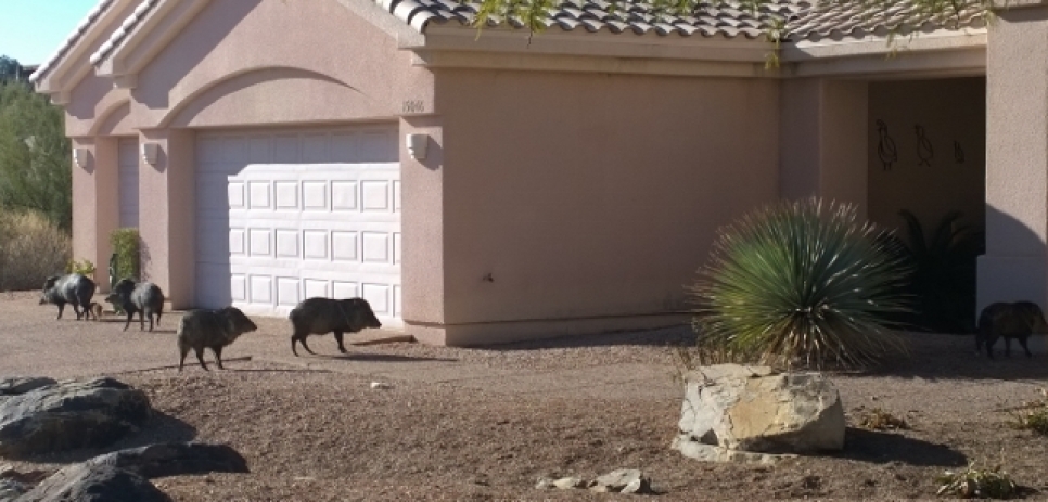
The following day we took the opportunity to chill and do some research for our upcoming weeks. We had lunch with Mitch at a nearby golf course and later in the afternoon we walked around downtown Fountain Hills and around the lake where the fountain is located. There were lots of ducks and herons enjoying the lake and we saw some guys practicing Frisbee golf for the World Championships that were coming up later in the week. We had a pizza from Papa Murphy’s for dinner where they make the pizza but you bake it in your own oven at home. It was really good so maybe this chain will come to Ontario at some stage (they are in western Canada right now). The next morning we said our goodbyes to Mitch and had to dodge 10 Javelina’s (including a baby) while loading the RV back up as they were eating the vegetation on Mitch and his neighbour’s yards! Come to the city to see the desert wildlife;-)


I most certainly did not climb anything close to the tricky wall. I humbly eat my cake.
LikeLiked by 1 person
Thanks Pete;-)
LikeLike
When we were at Lost Dutchman SP we hiked the lower levels, but not what you guys did, … WOW ! …. That would be too much for this cowboy. … Last July driving our Navion, (Mercedes), RV, home from the Yukon, our air filter and cabin filter became plugged up with dust from all the forest fires in BC . Had to replace them. The dust storm you went through might cause the same problem.
LikeLiked by 1 person
Thanks for the tip John, I’ll check the filters.
LikeLike
Great photos that dust storm looked nasty.
LikeLiked by 1 person
Very interesting, thanks for sharing. Great pictures … javelinas in town!? Didn’t expect that
LikeLiked by 1 person