This blog post should be called how plans can dramatically change! After Whitecourt and Fox Creek we stopped at the visitor centre in Valleyview AB and the supervisor was incredibly knowledgeable about the area. She suggested we stay at Kleskun Hill Natural Area that night and more importantly she told us all about Tumbler Ridge BC. Initially we didn’t have this side trip in our plans but hearing about this UNESCO Geo Park with all the hiking trails and waterfalls to see we decided to take the diversion to see it.
Kleskun Hill Nature Area (230 acres) contains some of Alberta’s northern most badlands as well as the largest parcels of native grasslands in the Grand Prairie Region. The eroded hills are quite fragile so you follow a marked trail through the area. We decided to do it that night when we arrived as the daylight was good for photos. They have also moved several historic buildings to the site which were fun to explore.
The next plan changer was that I came down with Shingles on my face! On the Thursday we arrived at Kleskun I had a few small blisters on my face but I was feeling dramatic pains from my teeth. My google searching led me to believe that I either had an infection at the root of a tooth or I had Shingles. After little sleep that night I said to Sharon that we needed to see a Doctor in Grand Prairie on Friday morning. We checked in with our health insurance company and they recommended a walk clinic we could go to. We waited just over 3 hours to see the Doctor (who was the worst Doctor we’ve ever seen) and she said in 5 seconds you have Shingles and I’ll write you a prescription for Valacyclovir. We filled the prescription and went to the tourist information centre so Sharon could see the exhibits and I could have a rest.
Sharon here, telling my side of the story now…You never know what a Tourist Office will be like so Joel knows I always like to stop in. This one had a very nice little museum that took you through the history of the area from the dinosaurs, to the Metis, the early homesteaders to the current oil and gas exploration. They had one fun special exhibit on Sasquatch so I tried to decide if Sasquatch is really out there. Just in case, I’ll be on the look out during our travels. Out front of the Tourist Office they have the 2nd largest sundial in North America. When we arrived the sun wasn’t out but luckily I was able to verify that it did actually work just before we left.
We decided to stay at Saskatoon Island PP just outside of Grand Prairie that evening and we were lucky to get a site as it was a weekend and the PP’s really fill up with locals. We ended up staying in the PP for 4 nights so I could rest and let the medicine do it’s work. The pain was absolutely horrendous and the blisters spread further across the left hand side of my face. However after 4 nights I was feeling strong enough to carry on so we proceeded to Dawson Creek with several stops along the way. We were both glad that the medicine worked quickly so we only lost 4 days of our journey.
While Joel recovered I walked all the trails in the park. Saskatoon Island PP was one of the first Provincial Parks in Albert, established in 1932 to protect the Saskatoon Berry. The park was originally an island but in the 1960s the water level dropped and the island was now connected to the mainland and there were two lakes formed. I was lucky to have my first moose sighting on the trail but wasn’t fast enough to get a photo. The rest of the time I cleaned/organized the RV (that doesn’t take much time with such a small space) and read a book. Lots of campgrounds and tourist offices have a book exchange so I had a new book ready to read.
Our first stop after Saskatoon Island PP was in Wembley AB to see the newly opened (2015) Philip J. Currie Dinosaur Museum. This museum has interactive exhibits, a palaeontology lab, a National Geographic Theatre (only one in Canada), and a great restaurant (Dine-o-saur). The museum was built here as they found a very well preserved bonebed, dating back 72 million years, in the Pipestone Creek area close by. We toured the exhibits and since no one wanted to watch a movie at 11 am the front desk lady let us pick what we wanted to see so we selected Sea Monsters. The movie covers the life of a Dolichorhynchops in the late Cretaceous period, 80 million years ago, and the other sea life she encounters like Tylosaurus, Xiphactinus, Cretoxyrhina, and Ammonites. This whole area was called the Kansas Inland Sea but when the sea shifted the fossils were left on the sea bed to be rediscovered. After the movie and lunch we completed the rest of the museum. There were lots of locals in the restaurant for lunch (a sign the food is good) but very few in the actual museum.
The next stop on the tour was Beaverlodge to checkout the worlds largest beaver that is 15ft tall weighing in at 3,000 lbs. We also visited the visitor centre and looked at their historic displays which showed a baby named Dwight Smith (my brother’s name) who was born in 1955 so now I can say my brother is older than me😉 After that we went to Valhalla Centre which was a Norwegian area and had the Melsness Mercantile Café and Museum. They had lots of trolls out front and we had a slice of pie in the café but the museum was closed for renovations. We also got an amazing fresh loaf of whole grain bread which seemed like it weighed several lbs! Next, after a bit of back tracking was the Hythe Tourist office and museum but it was closed. The building was built in 1910 and then converted in 1917 to a home for a mail order bride.
We crossed from Alberta into British Colombia so here are a few fun facts on BC:
- BC has a National Marine Conservation Area as well as 7 National Parks and nearly 650 Provincial Parks
- BC was the 6th province to join the Dominion of Canada in 1871
- The transcontinental railroad came across BC in 1885
- Our friends Martha and Jim said that BC stands for “Bring Cash” as everything is more expensive in the remote area where they have their cabin😉
In the village of Pouce Coupe we stopped at the visitor centre and museum (in the old train station) to look around and we were lucky enough that the manager stopped cutting grass and escorted us through the various outbuildings giving us the history of the main settlement for Northeast BC. Also in the town was a really cool curved wooden trestle bridge built in 1930 over the Bissette River but no longer in use.
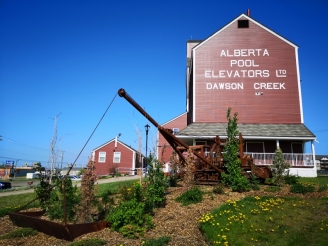
We carried on to Dawson Creek and checked into the Norther Lights RV Park and then toured around the downtown area and got supplies the next morning. There are two main Mile 0 marker signs for the Alaska Highway, one at the grain elevator and tourist office and the other in the downtown area. We did a historic walking tour of the downtown and stopped in the Alaska House Museum to look at the exhibits and watch the 1 hour movie on the making of the road.
In 1942 the US government was worried about Japan invading through the Aleutian Islands and in turn to Alaska so they wanted to build a highway to connect the remote airstrips that led to Alaska. They assigned 11,000 troops to complete the 2195 KM route and gave them just 8 months to complete it. The reality is that they really didn’t understand how to deal with muskeg and permafrost areas so they were trying to invent solutions. The conditions were horrendous, especially as they got into the cold temperatures in October. When they were done the US military claimed a large success in order to boost the campaign of being prepared for a Japanese invasion. The reality though was that the road was really not ready to be used as it had sections with 24% grades and in the following years 134 bridges had to be rebuilt due to poor structures and being washed out. In 1992 they removed 132 curves in section of the road to make it safer.
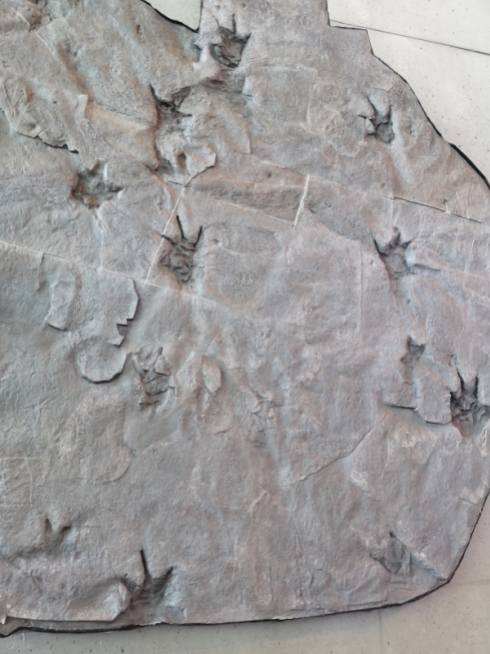
After leaving Dawson Creek we headed about 120 kms south to visit Tumbler Ridge which is a UNESCO Global Geopark. A Global Geopark is an area that UNESCO designates with sites and landscapes of international geological significance. Tumbler Ridge is only the second Global Geopark in North America. It has 34 accessible geosites across 21 destination areas which includes waterfalls, rock formations, alpine meadows and lakes, canyons, mountain summits, and dinosaur trackways. Two teenagers found the dinosaur tracks in 2000 and that really kick started this area to become significant. The key difference between a Geopark and a National or Provincial Park is that there are no restrictions on the land use. As we headed south our first stop was to do the Murray Canyon Overlook hike which was about 5 kms in total with great views of the Murray River valley. We went to the Lions Flatbed Creek Campground just outside Tumbler Ridge for the night and we were the only campers in our loop with a beautiful site right by the creek.
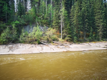
The next morning I used the creek water to test out my new portable high pressure washer to clean the bugs off the windshield and it worked quite well😉 We had several hikes planned for this day including the Flatbed Cabin Pool Dinosaur Footprint Site, Flatbed Creek Peat Site, Overhanging Rock Pool, Top Pool, and Flatbed Falls. We were the only people on the trails until the very end where we saw a school group just starting off. We had seen the Dinosaur Trackways in the Museum but I have to say to see the actual footprints in real life was incredibly cool! All the trails in this area have pamphlets for each hike and there was a very detailed map of how to find the dinosaur tracks. The Peat site was also interesting as they had several display boards with the information on the fossils they had found in the peat. If the water was a bit warmer it would have been fun to swim across and sit on the Overhanging Rock but we settled on the little rock by Top Pool. Once we had returned on the trail we took the side cut to see Flatbed Falls which was a 1 km downhill hike and of course what goes down must come up.
We back tracked a bit on the road so we could do the hike to Quality Falls which was relatively short at 2 km but the worst part was getting the RV down into the parking lot as everything was rocking and rolling. The walk was interesting as there were ferns everywhere and lots of lichen in the trees. The falls was quite pretty when we got there as the sun was hitting it just right. We went to both the upper and lower view areas to see the 10 m falls. Our total hiking for this day was just under 19 KMS.
After Sharon had her mandatory visit to the visitor’s centre we headed out to Gwillim Lake PP for the night. I tested out my new Bugs-Away shirt while cooking dinner on the BBQ (the shirt worked, now I need to buy a hat).
In the morning we did the lakeshore trail hike around the campground before checking out the viewpoint on the way out. Then we drove up the road to Martin’s Falls to do the 3 km return hike. It reached about 28 C by the time we were making our way out of the valley so it was nice to start the generator in the RV and turn the AC on and have a shower and lunch before heading out. The advantage of having your “house” with you at all times.
Our next stop was Chetwynd to see the wood carvings. We parked by the Visitor’s Centre and it was by far one of the best we have been to so far. They had knowledgeable staff, a room with couches to sit and connect to the internet, free coffee/water/snacks, book exchange, and an artisan area just to mention a few things they offered. In 2005 they started a wood carving competition, since then it has grown and today they get wood carvers from all over the world. This is why Chetwynd has over 200 carvings on display throughout the town. They use red cedar as it cuts very smoothly. The artists have 32 hours over the competition weekend to work on their carvings. They put the most recent carvings on carvers’ row and the rest are moved to permanent locations throughout the town. The winners receive a cash prize and an invitation to return for the competition.
During the winter at home, Sharon met Martha at a Women’s Institute meeting and they started talking about their travel plans. It was then that they realized they would be in Northern BC at the same time. Martha generously extended an invitation to visit her and Jim’s cabin at Moberly Lake. Invitation accepted and a wise decision. What a beautiful place to relax and enjoy. Good conversation, great food and of course a drink or two. After a dinner the first night we headed out to do a tour of the Moberly Lake area.
The next day Jim wanted to take us to see the W.A.C Bennett Dam so we decided to stay put another day to enjoy being toured around. Our first stop was the Hudson Hope Bridge so we could see the Peace River Canyon Dam. This dam only has 4 turbines but they are very large so it can still produce a large amount of electricity.
We carried on through Hudson Hope and turned to go the 24 kms to W.A.C. Bennett Dam. After we cleared the security gate we looked around in the Museum while we waited for our 2:30 guided tour. There was a sad video in the museum talking about the impacts the dam had on the First Nation peoples in the area when the reservoir was flooded. It actually took 5 years for the reservoir to completely fill up.
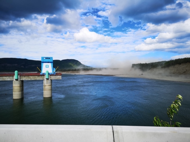
The dam is the world’s largest earthen dam and goes 2 kms across the Peace River and the base of the dam is 1 km wide. The water reservoir is also BC’s largest. The dam has 10 turbines and it produces about 25% of BC’s hydro. The water drops about 500’ down the Penstock shafts to turn the turbines and then the water exits through the manifold and in turn the tailrace tunnel. The guided part of the tour consisted of a movie and a bus ride to the base of the dam and all the way inside where we could walk around to see the tops of the turbines. After the tour was over we were allowed to actually drive all the way across the dam to a viewing point on the far side. Definitely worthwhile to visit this very unique dam.
On the way back we stopped at Dinosaur Lake to have a bit of refreshment before heading back to the cabin.
As I mentioned at the beginning of this blog sometimes plans have to change. The next morning we were going to leave Martha and Jim’s cabin and back track to Dawson Creek and head up to Yellowknife and Wood Buffalo NP in the North West Territories. We had been monitoring the forest fire situation in High Level where they had evacuated the town. Based on the latest news they had closed several other roads and also had closed Wood Buffalo NP. We had to make the really difficult decision to abandon our hopes to go the NWT at this stage in our trip and instead start heading along the Alaska Highway towards the Yukon and Alaska. We hope at some stage we’ll be able to return to see the NWT. Go with the flow as they say😉












Hi Joel and Sharon…have been enjoying your blog, as you progress on this journey. Always fascinating to see where you are and what you are encountering. Wise decision to let the shingles meds do their work; hoping there are no lasting effects. Loved the waterfall pictures and the carvings are amazing! At first I thought Joel was wearing the bright red shoes while playing the piano and Sharon with the Ken Dryden like carving is so great! Having not been on this route personally, I feel privileged to ride along with you two. Thanks so much! 😊💕 Continued safe travels and warm hugs😎☘️☀️
LikeLiked by 1 person
Really enjoyed your blog and pics this looks like a must do trip. Stay well and enjoy, looking forward to the next post.
LikeLiked by 1 person
Pete and I have been that route, but with your blog are seeing it for the first time. See what you miss when you travel with an organized tour. Looks wonderful.
LikeLiked by 1 person
Excellent report as always, love the dinosaur stuff. Cool that the arctic ocean and Mexico were joined by a giant river. Too bad this isn’t still there, be easy for Trump’s wall.
LikeLiked by 1 person
Thanks everyone for your comments, it’s like getting mail while we’re traveling so we really enjoy the feedback 😁
LikeLike
Glad to see you healthy at the end of the episode, Joel.
I hope your pain doesn’t persist anymore.
It’s terrific the changes on a trip, but we wish you good ones for the rest of your journey.
We hope that “Plankton” will take you to fantastic places…
Great, your 19 km hike on the dinosaur trail with all these waterfalls!
You must start having long days as you approach the Yukon.
Take care
Patrick and Marie-Jeanne
LikeLiked by 1 person
Thanks Patrick and Marie-Jeanne, pain is gone so that’s good. We’re in Fort Nelson BC now and will head over the mountains over the next few days so looking for clear skies😉
LikeLike
Thanks for the update of your travels. Very neat wood carvings at Chetwynd. I like to go into the visitor centres too 🙂
LikeLiked by 1 person
Good read, I like the nice touch of Sharon’s inserts, more please!
I got confused at the beginning when you mentioned Tumbler Ridge, BC., and staying at Saskatoon Island PP. I think to myself, how come they went from Alberta to BC, then went back into Saskatchewan (Saskatoon!). I’m learning lots of geography.
How can she be the worst doctor you ever had, when she correctly diagnosed you in 5 seconds and gave you the right medication to fix you up?
LikeLiked by 1 person
The Doctor had zero bedside manor Danny, more to tell later.
LikeLike
Liked the wood carvings, particularly “The Eldest Of The Ents”🤓. Sharon’s lucky she didn’t get the Shingles , they can be quite contagious I believe. Got them 30 years ago but on my back, which is a common spot, radiating from the spine, not fun. I echo Danny’s comment, more Sharon, no offence Joel. Variety. Glad that I got an honourable mention😉😁. Would like to visit the Dino park, cool stuff! Continued happy safe travels💞🚌👍🏻
LikeLiked by 1 person
Ok everybody asking for more Sharon so I guess I’m too boring 😁 I’ll make her do more work on the blog😉
LikeLike
Goodness Joel- shingles for gawdsake! We’re glad to know that the meds have improved it. Hope you get through it fast. 👍 I loved Sharon’s inserts- more please (I can hear both your voices in the writing). And see that she picked up a Cretaceous friend. 😀. Loved the Chetwynd wood sculptures….and laughed out loud at young Dwight Smith’s photo!
Onward ho – NWT will be ready for you on return, I’m sure!
LikeLiked by 1 person
Thanks Ella, we’ve been offline for 4 days, all seems good now. Crossed into Yukon today.
LikeLike
Good to hear – thanks for the update, take care (both of “youse”) and keep on truckin’!!!
LikeLiked by 1 person
Love the travel blog.
Shingles, very painful.
Love the carvings, and imaging eating that beaver tail.
We are home now after a successful 4+ months on the road.
Have to start planning our next trip.
LikeLiked by 1 person